Most salmon faeces and uneaten feed pellets settle to the seafloor in the immediate proximity of the cages, where they are processed and assimilated by the animals that live within the sediments.
Water depth, currents and farm production levels are important factors that determine the waste footprint’s extent and direction.
Extensive research in Tasmania has documented how much particulate farm waste affects invertebrate communities and sediment chemistry.
The research confirms that most organic enrichment and significant impacts are concentrated immediately below and within 35m of actively farmed salmon cages, and this decreases with distance from the cage.
As the industry continues to grow and evolve through new production approaches and expansion into new areas, maintaining high environmental performance requires understanding how farming in new areas/environments and changes in farming practices might change environmental interactions.
A major focus of our research at IMAS in recent years has been to ensure that monitoring and the indicators of impact remain fit for purpose. Our findings are available here.
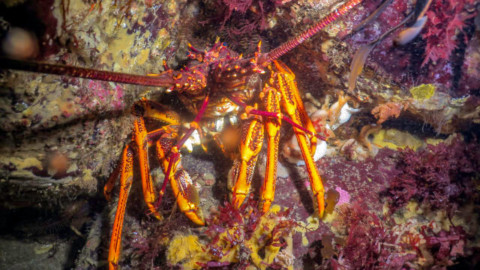
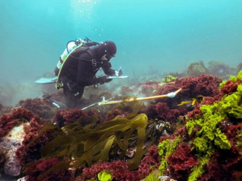
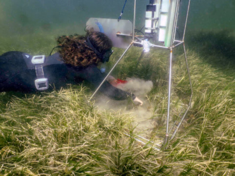
Since 2019, IMAS has been deploying cameras on the seafloor immediately adjacent to salmon cages, to show how the animals and sedimentary environment respond to, and process, farm waste. The cameras take images at set time intervals and can be deployed for up to six months.
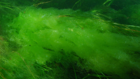
Watch the video (above): In the time lapse sequence shown here, images were captured every 30 minutes over 3 weeks. First, you’ll see some salmon pellets (light brown blobs) that we released for the purpose of this study, which are consumed by invertebrates like seastars and sea slugs, and fish like Jack mackerel and Rock cod. You’ll also see salmon faeces (darker brown/orange blobs) which are quickly consumed by organisms like polychaete worms and burrowing amphipods. The dark grey-black mounds and burrows are likely to be created by burrowing Ghost shrimp, while the white/grey crusting is a mat-forming bacteria associated with enriched sediments.
Learn more:
It is well known that marine salmon farming practices result in the release of both dissolved nutrients and particulate organic material in the form of urea, fish faeces and uneaten feed.
The release of these materials has the potential to interact with rocky reef environments, with the likelihood and level of response depending on several factors. These include the farm’s location in relation to rocky reefs, the intensity of farming, the local hydrodynamics, and the sensitivity of the rocky reef ecosystem.
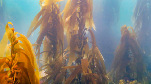
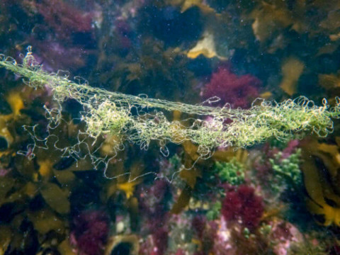
An early indication of nutrient enrichment includes the increased abundance and rapid growth of opportunistic algal species. By nature, opportunistic species are fast growing, can more efficiently make use of increased nutrient levels, and may out-compete other species.
A 2015 IMAS study published in Marine Pollution Bulletin found increases in opportunistic algae that grows on the fronds of larger algal species, called epiphytic algae, between 400m and 1000 m from salmon farms in the D’Entrecasteaux Channel.
This study led IMAS researchers to develop the rapid visual assessment (RVA) methodology that targets these indicator species and provides an early indication of organic enrichment from potential sources such as salmon farming. This method was used in a recent reef health assessment of the southern D’Entrecasteaux Channel.
Learn more
At IMAS, we use two main approaches for monitoring inshore reef health – the Edgar-Barrett biodiversity survey method and rapid visual assessment (RVA).
Developed by two IMAS researchers, the Edgar-Barrett method provides a full census of all fish, invertebrate and algae species at a particular site.
This provides a baseline of species abundance for a region, so scientists can track ecosystem changes over time.
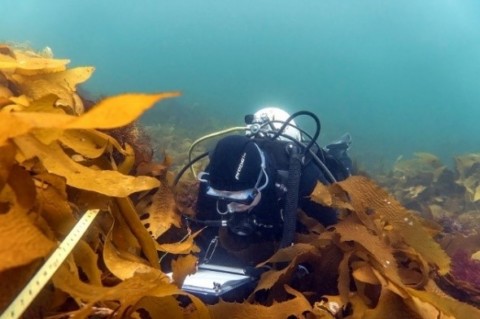
Scientists have used this method for over 25 years in southern Australia and across Tasmania, including at sites in Storm Bay. Results can be compared to a broader database, and local impacts can be separated out from more regional or broader-scale changes like climate change.
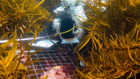
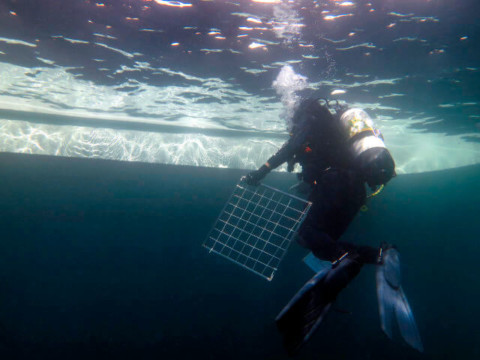
Here’s how it’s done: A diver does a visual census along a 200m transect line, counting and measuring all fish species within five metres of the transect on both sides of the line. They also count invertebrates and cryptic fish within one metre of the line, and measure species that are commercially or ecologically important.
Meanwhile, algal diversity is assessed by point-count using a 0.25 m2 quadrat placed every 10 m along the transect line.
This method was used for the FRDC Storm Bay Observing System Project to establish baseline conditions of inshore reefs at sites throughout Storm Bay, to assess potential interactions with the development of salmonid farming in the region.
IMAS recently developed the RVA method, which targets functional groups and indicator species that are related to organic enrichment. RVAs provide an early indication of organic enrichment on temperate reef ecosystems, and are conducted twice a year. The timing is based around the likely response of the macroalgal community to nutrient enrichment from salmon farming.
These are more targeted assessments, where a site is scored based on 15 parameters that assess reef function, including basic reef health indicators such as canopy cover and substrate condition, and parameters expected to respond in some way to changes in nutrient availability or sedimentation regime, such as nuisance or opportunistic algae cover and food-web effects.
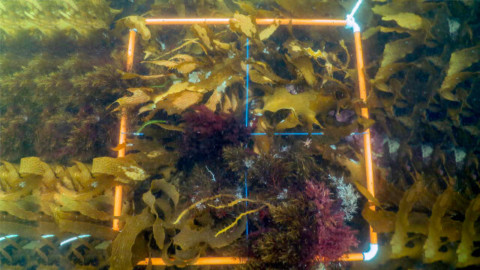
Sites are assessed using 1m2 quadrats, a technique designed to detect shifts across several functional parameters simultaneously. This gives a more complete picture of a reef’s enrichment status than only examining singular parameters.
We are currently using RVAs in our Storm Bay Observing System Project and also recently to establish the reef condition in the southern D’Entrecasteaux Channel.
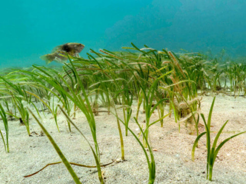
IMAS is currently undertaking research on the potential interactions between salmon farms and seagrass beds and rocky reefs. This includes mapping the distribution and extent of seagrass beds and the species on deep reefs annually with ROVs and drones, and assessing the levels of nutrients in seagrass and epiphytes using stable isotope analyses.
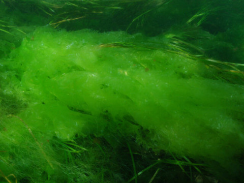
The growth of ‘nuisance’ algae in the shallow subtidal and intertidal zones is a frequent phenomenon. It is caused by nutrient input from:
Nuisance algae species perform an ecosystem service by mopping up excess nutrients and, in natural conditions, they tend to be short-lived.
Issues occur when nuisance algae blooms are persistent, which disrupts normal ecosystem function. This disruption happens because the fast-growing algae draws oxygen out of the water column, causing localised low oxygen levels and reducing light and nutrient levels for other photosynthetic organisms
While the release of nutrients from salmon farming may be one contributing factor to nuisance algal blooms, the level of response will vary depending on the proximity to farming, the intensity of farming, the local hydrodynamics, and the relative contribution of other natural and anthropogenic nutrient sources.
This makes it challenging to untangle the relative contribution of different factors to nuisance algae growth.
IMAS scientists are currently investigating the drivers of nuisance algae blooms, especially in Port Arthur and the D’Entrecasteaux Channel. We are also establishing and testing visual assessment methods and using stable isotope tracer techniques to identify the major sources of nutrients (see Monitoring the health of our inshore reefs, above).
Our initial findings suggest the response of nuisance algae species is greater closer to salmon farms, particularly in more sheltered and poorly flushed locations, but more regional effects are the subject of ongoing research.
In Spring 2016, IMAS reported a major decline in oxygen levels in bottom waters of Macquarie Harbour and a deterioration in sediment conditions, including the presence of bacterial mats and a loss of fauna.
However, the impacts were greatest in the deeper regions of the Harbour and at sites further from the ocean entrance. Meanwhile at the most southern lease, we observed a loss of fauna in the vicinity of the salmon farm.
While we’ve seen seasonal declines in oxygen levels and how this effects animals living in the sediments, most changes are in the deeper central regions of the Harbour, rather than in its vast shallow reaches.
After the low oxygen events, we’ve seen good recovery of sediment conditions and fauna numbers in the affected areas, and recovery seems faster where oxygen conditions are better. The shallower areas are a source of new fauna recruits and juveniles, so are helping this recovery.
The recovery of bottom water oxygen levels has not been as obvious, with large seasonal fluctuations and lower oxygen levels each spring. Since late 2020, it’s encouraging to see some of the most significant recharge of oxygen levels in the harbour, with improved levels throughout 2021.
Knowing how long these levels are sustained is important. At IMAS, we manage the monitoring strings of environmental (including oxygen) sensors. These provide real-time information on oxygen levels across the whole water column, at sites throughout the Harbour – and the data is critical to both farm management and regulation.
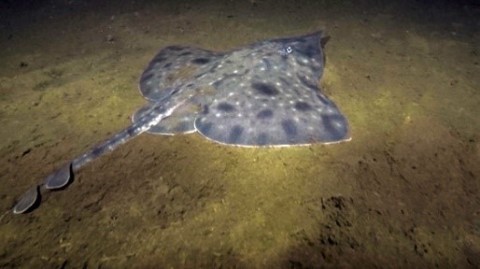
An important focus of our research is to determine the current population status of the Maugean skate. We are currently testing a number of novel non-invasive technologies to underpin ongoing monitoring of this very rare micro endemic species which is only found in Macquarie Harbour.
Learn more:
To help ensure that salmon farming in Storm Bay is sustainable, IMAS is leading a major project to develop and implement a comprehensive environmental monitoring program.
This program is designed to assess the interactions between salmon farming and all the surrounding habitats, including the water column, soft sediments, reefs, and seagrass.
Measurements of a wide range of environmental performance indicators are being taken across multiple sites at both local (lease) and regional (bay) scales.
Our IMAS team is:
The information we collect will be used to calibrate and validate a biogeochemical model which CSIRO is developing for Storm Bay.
This model will be used by both the regulators and the industry to predict the effect of different salmon farming inputs on the surrounding habitats, under varying conditions and with different management scenarios.
Learn More:
EPA Tasmania is responsible for the environmental regulation of the Salmon industry. All farms must hold an environmental licence to operate. This sets out the environmental conditions and standards, including their monitoring and reporting requirements. Licences can be found on LISTmap.
The EPA receives environmental monitoring reports from the salmon companies on environmental performance (see monitoring below), and undertakes its own monitoring.
Like most farming practices, aquaculture may introduce nutrients into the environment and this can have a significant impact on coastal marine systems.
In Tasmania, biomass and nitrogen caps are used to manage excess discharge from fish feed, fish faeces and urine.
For example, in the D’Entrecasteaux Channel and Huon River Marine Farm Development Plan area, the EPA allocates a limit on how much dissolved nitrogen salmon aquaculture companies are allowed to input to the environment. This is based on the known nitrogen content of feed and the amount released as fish faeces and urine.
Environmental monitoring detects any adverse effect on the environment both in proximity to individual farms and at the regional scale.
All salmon farming sites in Tasmania are required to undertake regular visual monitoring of the seabed, both under and around the salmon pens and at the compliance sites 35 metres from the lease area.
Visual impacts monitoring is done with remotely-operated vehicles fitted with high definition cameras. This must show no significant visual, physico-chemical or biological impacts at or extending beyond 35m from the boundary of the lease area. The visual assessment method was developed and validated by extensive research at IMAS in the early 2000s.
Environmental surveys are triggered if significant visual impacts are detected, such as the presence of fish feed pellets, bacterial mats, gas bubbling and numerous opportunistic polychaetes on the sediment surface. These surveys are conducted at points further away to assess impact.
If a significant impact is detected within or outside the lease areas, the EPA may require management responses and further investigation
The broad-scale environmental monitoring program (BEMP) is conducted in each salmon growing region to detect environmental changes in the water column and on the seabed at a regional scale. Find out more about the EPA’s BEMP monitoring.
IMAS continues to play a lead role in developing and validating monitoring methods, such as the Rapid Visual Assessment method discussed above, and new methods for monitoring the condition of deep reef and seagrass habitats in Storm Bay (see below).
When new marine farming zones are proposed, an initial zone assessment must be conducted. These detailed descriptions of seabed habitats ensure no spatial overlap exists with sensitive habitats like reefs.
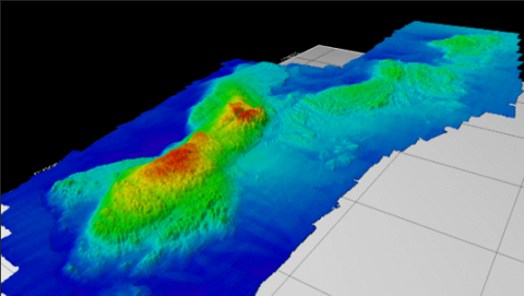
A zone assessment involves a seabed mapping survey conducted using acoustic technology. Recently, standards have shifted from single-beam echosounders to multi-beam technology which provides full coverage of the seabed. Based off sonar technology, acoustic seabed habitat mapping has been steadily developing worldwide over the past two decades.
This data feeds into a seabed habitat map of Tasmania*, which is used in assessing proposed marine farming zones in Tasmania. The maps specifically created for zone assessments include a local spatial buffer around the proposed zone, to ensure seabed habitat is mapped in the zone’s immediate vicinity.
IMAS is currently conducting a bay-wide mapping exercise in Storm Bay, to fully describe and map seabed habitats. This updates and extends the coverage of Seamap Tasmania in the region.
Ongoing research is examining the diversity of seabed habitats in Storm Bay, sediment dynamics in this high-energy environment, and the distribution of habitats in relation to the existing marine leases and associated monitoring efforts.
*The IMAS-based, award-winning Seamap Tasmania project has mapped coastal habitats for over a decade, using single-beam echosounders up to 1.5 km from the coast or 40 m depth. Today, this habitat map is still the most comprehensive description of seabed habitats in the south, east and north of the Tasmanian coast – and has morphed into Seamap Australia which standardises seabed classification across Australia.
During their feeding cycle, salmon release dissolved inorganic and organic nutrients into the water, which is dispersed by water currents.
Dissolved salmon waste is mainly ammonia, which rapidly transforms into ammonium or nitrate. Both of these active biological compounds transform as they cycle through the ecosystem, with ammonium quickly taken up by algae.
Predicting the path these nutrients take while still reasonably close to the salmon farm is beneficial for farm management and planning purposes.
Researchers use biogeochemical and hydrodynamic models to look at broader scale system responses and issues of sustainability.
Particle tracking models can be used to predict nutrient footprints. CSIRO’s Connie3 is an example of a decision support tool developed by researchers to enable more sustainable management of our marine systems.
Connie3 has been used to simulate dissolved inorganic nitrogen released from salmon pens, with a decay rate for particles that can simulate losses from algae uptake and chemical reactions.
To help further develop and validate the models IMAS and CSIRO have conducted high resolution nutrient mapping around several leases in southeast Tasmania.
Hydrodynamic models, developed and validated by CSIRO’s Coastal Environmental Modelling team, simulate water currents in the D’Entrecasteaux Channel, Huon Estuary, Derwent Estuary, Macquarie Harbour and Storm Bay.
Biogeochemical models have been used extensively for water quality modelling and assessing impacts of industry, to understand the interaction between salmon aquaculture and the coastal marine environment in Tasmania. A biogeochemical model is currently being developed for Storm Bay.
Direct observations taken around farm leases are compared to model results to evaluate the accuracy of the predicted footprint. This is fundamental to ground truthing predictive tools.
Introduction
Our marine environment is important for a wide variety of activities and uses. The degree to which activities can occur together in the marine environment varies, ranging from fully integrated ocean multi-use to exclusion zones where only a single user can operate.
This is why researchers at IMAS and across the University of Tasmania undertake research to develop decision-support tools to aid spatial planning in the marine environment.
Two key and related areas include sector-based spatial planning and more broadly, marine spatial planning – and while they sound similar, they have different outcomes. Let’s find out why.
What is spatial planning?
Spatial planning can be used to identify locations or areas for the uses and values present in the marine environment. By doing so, it can be used to determine suitability for certain activities, while also minimizing conflict with other users or values.
Spatial planning is an important tool for assisting with decisions about the allocation of marine space for activities like aquaculture.
Geographic information system (GIS)-based decision support tools play a fundamental role in collating, visualising and analysing this information.
Is sector-based spatial planning for aquaculture the same as marine spatial planning?
Sector-based spatial planning is used to identify the needs of a specific sector (or sectors) within a defined area. Sector-based spatial planning could be applied to any activity or value which uses space within the marine environment, including aquaculture.
While the focus is on single sectors, or multiple sectors considered at the same time, the process also identifies the needs of other users and values (such as ecological value) within the area. This is because they relate and interact with the sector(s) of interest. This information can be obtained from individual stakeholders.
The outcome of this process is to identify potential areas where specific activities could occur or, in the case of conservation planning, identify areas suitable for conservation.
Marine spatial planning (MSP) is a broader and more comprehensive process than single-sector spatial planning.
MSP is a process involving public participation that allocates marine space to different activities and uses. It aims to support economic development while ensuring marine resources and the environment are conserved for future generations.
MSP is based on principles of social, economic and environmental sustainability.
MSP involves public consultation with interested parties where objectives on how the marine environment could and should be used are defined. This process is often led by government, with significant involvement from others, including Traditional Owners, industry and business associations, environmental non-governmental organisations, academic researchers, research organisations, community members and community interest groups.
The outcome of this process is a marine spatial plan that identifies specific areas/zones where activities can or cannot occur. These are meant to be ‘living’ plans with scheduled reviews to ensure they still meet objectives set by interested parties.
Single sector spatial planning and MSP – working together
Outputs from sector-based spatial planning can be used to support evidence-based decision-making in an MSP process.
Single-sector spatial planning can also occur on its own without the necessary involvement of a comprehensive MSP process. This can occur when actual or potential conflict between uses is not as complex and could be mitigated through other management strategies, such as ecosystem-based management or conservation planning.
UTAS spatial planning research
Researchers at IMAS and the Centre for Marine Socioecology (CMS), together with the School of Geography, Planning and Spatial Sciences, conduct research projects developing decision-support tools to aid spatial planning in the marine environment.
Two sector-based projects completed in recent years include:
1. The Pilot Marine Spatial Assessment Tool (Ross et al. 2020) was developed to evaluate options for assessing and balancing marine use change in the D’Entrecasteaux Channel in the southeast of Tasmania.
The pilot project was a collaborative project with the Department of Primary Industries, Parks, Water and Environment (DPIPWE) under the Sustainable Marine Research Collaboration Agreement (SMRCA).
2. The Statewide Finfish Aquaculture Spatial Planning Exercise involved developing and applying a decision-support tool (based on the Pilot Marine Spatial Assessment Tool) to help decision makers better understand the biophysical suitability of the Tasmanian marine environment to host finfish aquaculture. Additional information on the project can be found in the report's supplementary information.
It also helped understand the potential for conflict with other users should an area be biophysically suitable for finfish aquaculture operations.
The project included information about other existing marine uses, activities and areas of ecological value to help decision makers consider trade-offs between these and any potential future finfish aquaculture development.
It was a collaborative project with the Department of Primary Industries, Parks, Water and Environment (DPIPWE) under the Sustainable Marine Research Collaboration Agreement (SMRCA).
---------------------------------------------------------------------------------------------------------------------------------------------------------------------
For more information on marine spatial planning:

Social license for salmon farming
‘Social License to Operate’ (SLO) is a new term being used in natural resource development around the world. SLO is being increasingly found across aquaculture research, policy and activism, similar to what occurs in the mining, forestry and renewable energy industries.
SLO is granted when a project has broad, ongoing approval and acceptance from the broader community. However, while society may grant an SLO, local communities are key stakeholders in the process and need to be considered. This is due to their proximity to the project and sensitivity to its effects.
SLO is a growing area of research and many attempts have been made to understand its processes. IMAS research into what influences an SLO being granted in Australia’s fisheries and aquaculture sectors identified 16 determining factors, including:
For more information, read our 2019 report on Determinants of socially-supported wild-catch fisheries and aquaculture in Australia and our 2022 paper: A social license to operate for aquaculture: reflections from Tasmania.
IMAS research in this area is ongoing, with current projects investigating the role of wellbeing in SLO, communication strategies and measuring the level of acceptance in Tasmania.